Background
A petroleum release occurred from a former gas station which operated from the 1960s through 1981. In September 2003 during the installation of a water supply well located approximately 380 feet (116 m) from the former underground storage tank (UST) system, petroleum odors were identified in soil cuttings and groundwater from depths of 85 to 180 feet (26 to 55 m) in the borehole. This well and two additional water supply wells located between 560 and 615 feet (171 and 187 m) from the former UST system contained gasoline constituents exceeding drinking water standards. Subsequent soil and groundwater assessments at the site and surrounding area indicated the presence of subsurface impacts. Bedrock at the site is composed of foliated metamorphosed biotite monzogranite with the depth to the top of fractured but competent bedrock ranging from 60 to 80 feet (18 to 24 m) below ground surface.
The overlying saprolite and partially weathered rock includes residual structure from the parent bedrock with medium dip angles of 40 to 50 degrees, with more permeable layers providing preferential pathways for the migration of gasoline constituents to the fractured bedrock. Dissolved-phase hydrocarbons and light non-aqueous phase liquid (LNAPL) are present.
Soil removal conducted in May 2006 and March/April 2010 was limited to the area of the former UST system. Soil sampling results indicated gasoline constituents remained in the residual soil at levels above cleanup standards. The groundwater sampling results from monitoring wells installed in the regolith indicated a contaminant plume approximately 90 feet (27 m) wide and 190 feet (58 m) long; however, the water supply well sampling results indicated migration of gasoline constituents within the fractured bedrock to at least 615 feet (187 m) from the former UST system. Groundwater sampling from two monitoring wells installed within the upper bedrock did not indicate the presence of gasoline constituents; however, the wells appear to be cross-gradient or at a lower elevation than the plume with distance from the source area. While LNAPL was not identified in the source area, the concentrations of dissolved gasoline constituents suggested residual LNAPL is present within the regolith in the saturated zone.
Approach
Based on the limited historical soil and groundwater data, additional investigation was warranted to characterize the subsurface contaminant mass. AST and Atlas Technical Consultants, Inc. (Atlas) conducted a quantitative High Resolution Site Characterization (qHRSC) consisting of soil and groundwater sampling in March and December 2019 to evaluate the horizontal and vertical extent of LNAPL in the saturated soil. The purpose was to design a groundwater remediation pilot test including the injection of BOS 200+®. To investigate the saprolite and quantify the soil mass contributing to groundwater impacts, 13 overburden soil borings were completed with soil samples collected every 2 feet vertically for a total of 183 discrete soil samples. New monitoring wells were installed to delineate the lateral extent of the saprolite groundwater plume, and to assess the volatile organic compound (VOC) concentrations within the partially weathered rock (PWR) unit. Fifteen groundwater samples were collected. The data collected from the discrete soil and groundwater sampling provided information to assist in choosing optimal injection locations and remediation product loading. All samples were analyzed at the RPI Project Support Lab in Golden, Colorado at no cost to the project.
Based on the data collected from the additional investigation, a more detailed understanding of the subsurface lithology and hydrological connectivity between the overburden and PWR was obtained. In April/May 2021, AST injected BOS 200+® and amendments in 24 borings at 5-foot (1.5 m) spacings within a 600 ft2 (56 m2) area, with a target injection depth of 18 to 35 feet (5.5 to 11 m) bgs for each boring. Two shallow groundwater monitoring wells are located within the injection area.
The data collected from the sampling event was used to produce the qHRSC models in Figures 2, 3, 4, and 5 below. These models demonstrate the extent and magnitude of the impacted area. The qHRSC was used to strategically build the BOS 200+® design for this site.
Results
The results of the qHRSC provided a more comprehensive understanding of the total hydrocarbon mass present in the subsurface and identified additional data gaps. Groundwater sampling results from the two monitoring wells located within the injection area following the BOS 200+® injections indicated that the injections were successful in reducing concentrations of benzene and 1,2-DCA by more than 96 percent as seen in Figure 1 below.
Next Steps
Source area injection to treat saturated soil upgradient of the pilot area (RDC-2, RDC-3, RDC-4
and RDC-7)
• Source area injections completed 4/14/2022
• Continued monitoring of pilot test area, down gradient monitoring wells and domestic use wells
• Further investigation and delineation of impacts within PWR and bedrock zones
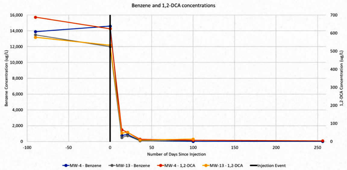 Figure 1. Benzene and 1,2-DCA concentrations
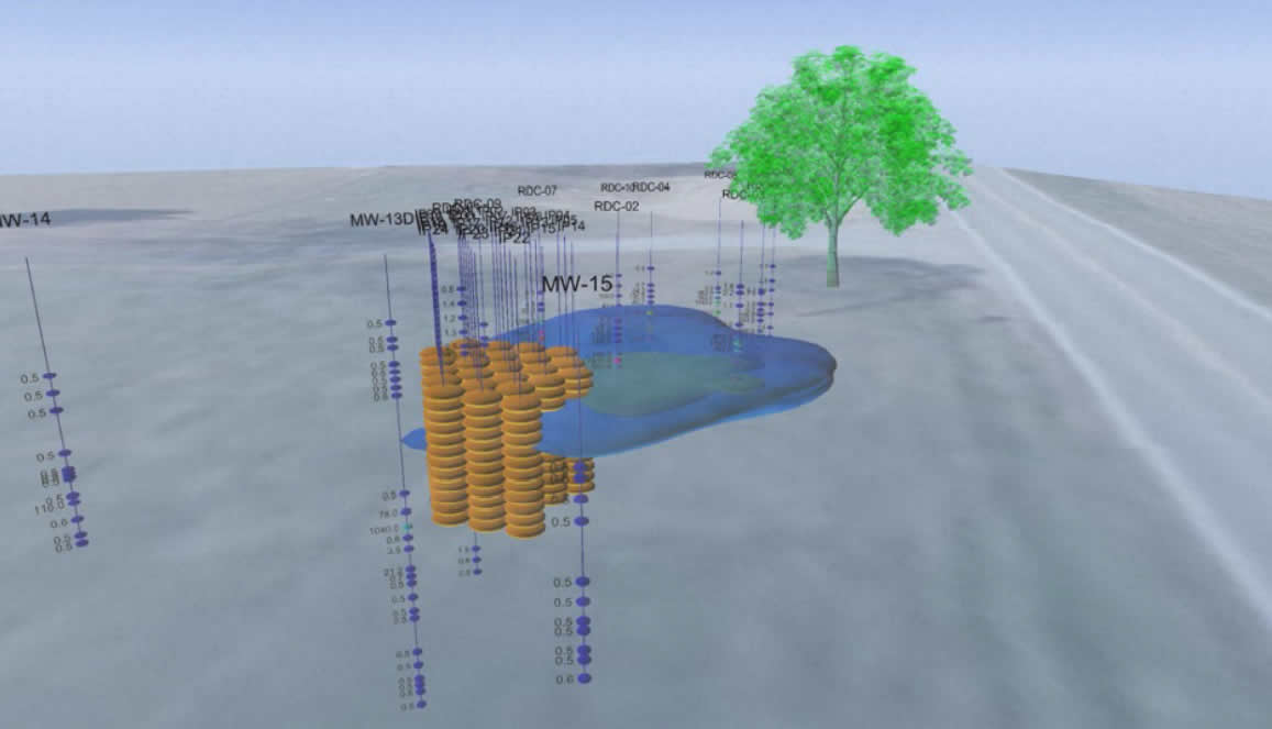 Figure 2. Benzene Plume with Pilot Injections
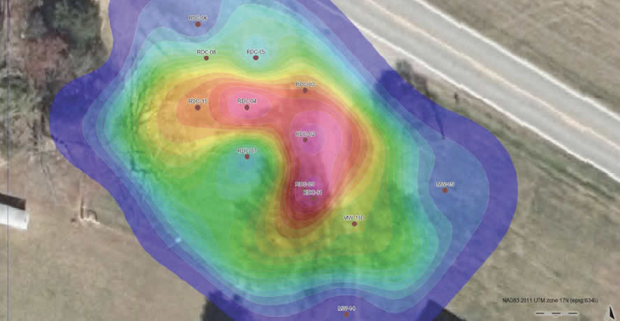 Figure 3. Groundwater Benzene Heat Map
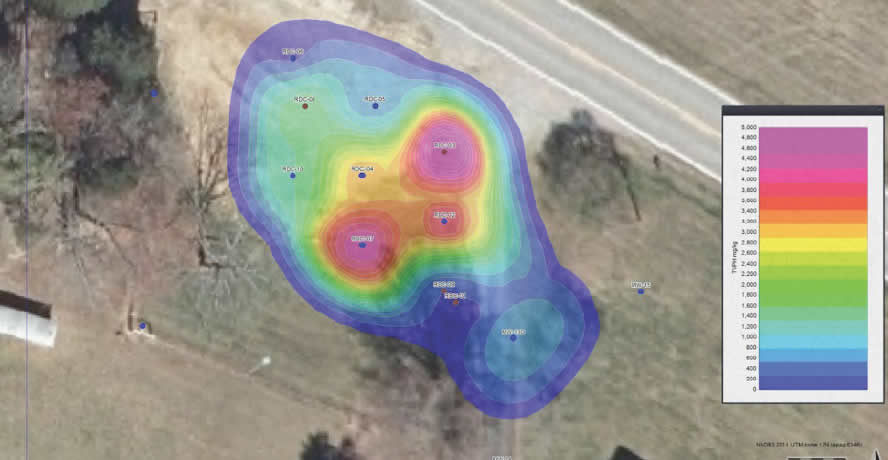 Figure 4. Soil Benzene Heat Map
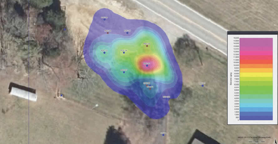 Figure 5. Soil TVPH Heat Map